One of the trips I've dreamed about has been flying home to Maine, landing at the airport that's pretty much down the street from my parents, and being at their house within minutes thereafter. My brother's in-laws planned a large barbecue on the Sunday of the long Labor Day weekend, so Jodie and I decided to load the plane and head north.
We originally intended to leave work early on Friday and fly to Worcester, Massachusetts, to see my littlest nephew for the evening, then continue on to Maine the following morning. I worked at home on Friday and watched the weather all day. The weather was nice, beginning about 100 miles north of our airport. At our airport, though, cloud ceilings were only a couple hundred feet above the ground, far too low to take off. I wished (again) for my instrument rating, as we could have taken off and been above the clouds within minutes. While our neighbors labored on in the gray gloom, Jodie, Millie, and I would have been bathed in glorious sunlight above a layer of cottony clouds..... Instead, we spent Friday night at the movies, and arose early on Saturday, hoping for better weather.
By the time the weather cleared for us to head north, it was noon. Even then, the flight was only marginally clear. We climbed through a hole in the clouds northwest of Baltimore, and stayed high above them until we were near the Connecticut border. Gaps between clouds were shrinking, so I slowed the plane, chose one of the last remaining holes, and spiraled down through.

Dodging clouds the rest of the trip, we touched down to clearing skies at Sanford (KFSM) exactly three hours after takeoff. My dad saw us pull up to the FBO and came jogging across the ramp to give us both bear hugs. We loaded the luggage into his car, covered the plane, and were about to leave when my brother's Tahoe pulled up. This was a big occasion - my first flight to Maine - and my nephews were enthralled by the idea that we had arrived, literally, out of the blue. It was only a few minutes before the plane was uncovered again and I was taxiing around the airport with three year old Emerson on his mom's lap, hand on the yoke. Judging by the self-satisfied expression on his face, I am quite confident that he believed he was in control. Alas, I have no pictures!
A year or so ago, when
I took my whole family flying, my sister-in-law, Brandie, had just given birth to Owen, my middle nephew, and didn't get to go for a flight. When asked if he wanted to go in the air, Emerson said no, so we left him with his dad while Brandie and I took a quick hop. We flew along Wells and Ogunquit beaches, then turned to see their house and my parents' house before returning to the airport. She loved it, and I had a great time finally taking her up.
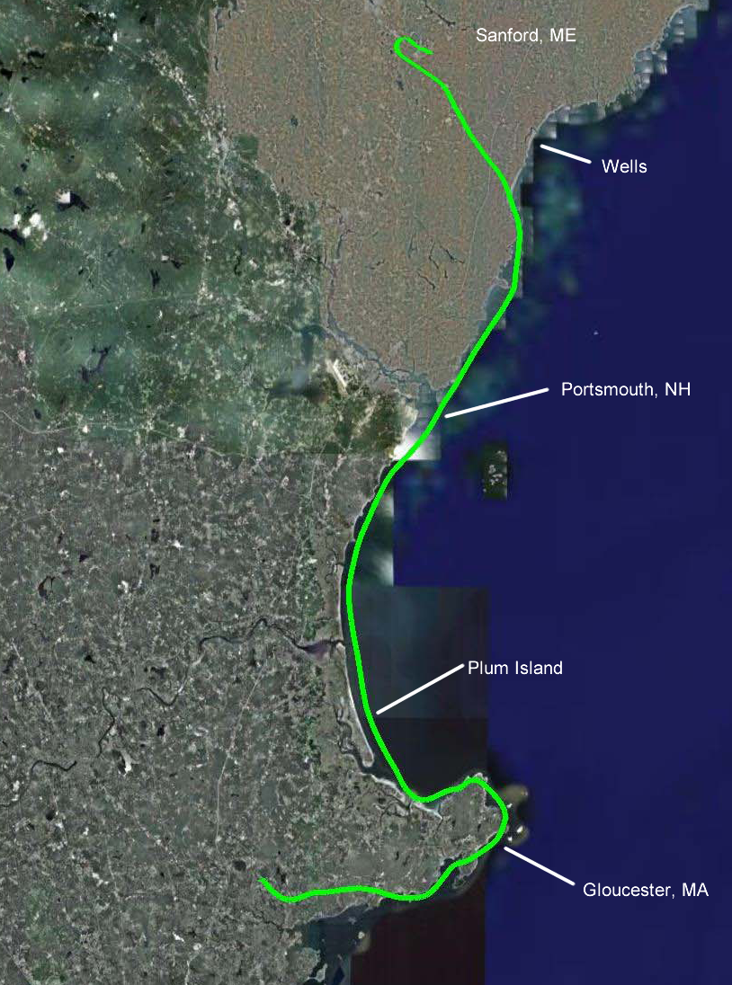
After a great weekend, my entire family escorted us to the airport late Monday morning. It was gusty but extremely clear, and the cluster of family stood on the ramp and waved as we took off and turned downwind toward the ocean. We followed the coast south, staying off shore a mile or so. All the coastal cities of my youth passed off our right wing: Portsmouth, Salisbury, Newburyport, Plum Island....

We descended to just 1,500 feet as the coastline turned east and north around Cape Ann -- Ipswich, Great Neck and Little Neck, Essex, Rockport, Annisquam, Gloucester, Magnolia, Manchester-by-the-Sea.... Looking down on this area where I went to college, memories flooded back with a density and intensity I hadn't experienced in a long time. I picked out the steeple of my college chapel, remembering when it was erected, and flew over the campus on a base leg into Beverly Airport (KBVY).

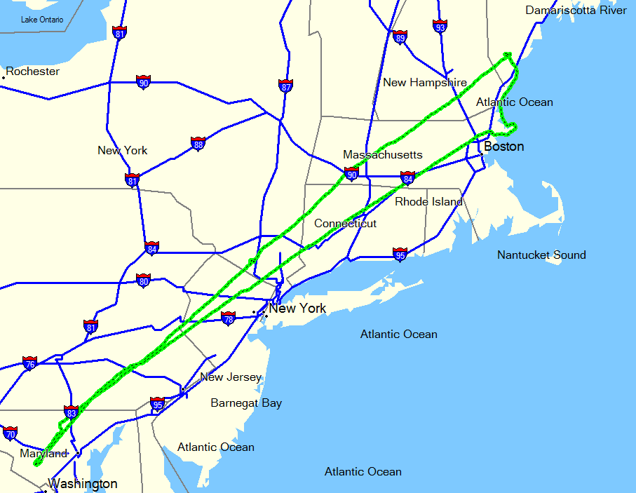
We had a wonderful lunch with our old friends, Ryan and Rachael. We talked about going for a flight, but given the hour decided to wait until next time. We were delivered to the airport and took off toward the southwest. Boston lay just off our left wing, and we climbed slowly as we cleared its airspace. With Boston still clearly visible, we passed Worcester on our right and leveled off at 8,500 feet. The straight line home gave us the grand tour of northeast cities: Hartford, New Haven, New York, Newark, Philadelphia, Baltimore.... The visibility was unlimited and we clearly saw the Statue of Liberty in New York Harbor. Philadelphia was a smoggy smudge, but still visible.

We had a tailwind that decreased as we headed south, but for a while we were seeing groundspeeds of around 200 mph. Only two hours and twenty minutes after taking off from Beverly, we touched down at Gaithersburg. THAT was the first time, and only time, that I have truly enjoyed traveling on Labor Day.